Recorded VCO
CyberGIS-Compute: Geospatial Middleware for Simplifying Access to High-Performance Computing
Date: Jul 27, 2022 Time: 02:00 PM (Central Time)
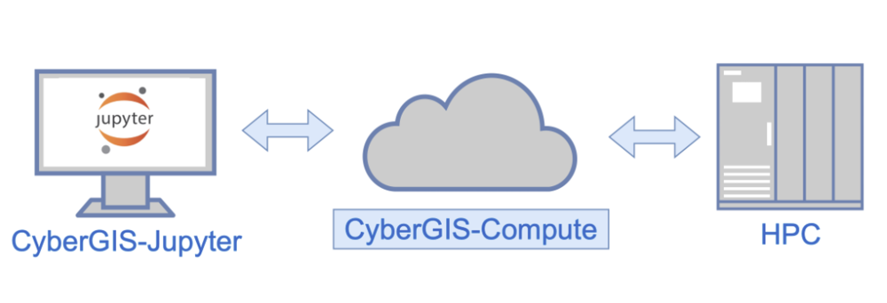
Geospatial research and education increasingly rely on cyberGIS and cyberinfrastructure to tackle computational and data-intensive problems. While cyberinfrastructure is invaluable to solving complex problems, the steep learning curve and increasing use of cyberinfrastructure in geospatial data-intensive sciences have widened the digital divide between technical and domain experts. In this VCO, we present CyberGIS-Compute – a key component of the I-GUIDE platform and an open-sourced geospatial middleware framework that provides seamless access to high-performance computing (HPC) resources through a Python-based SDK and core middleware services. CyberGIS-Compute is designed to give domain experts effortless access to HPC resources while enabling technical users to distribute computationally intensive workflows in an accessible and reproducible way. We will discuss the key concepts behind CyberGIS-Compute, demonstrate its capabilities with a use case of computing spatial accessibility, and discuss how your workflows can take advantage of CyberGIS-Compute and HPC.
Speaker Bios
Anand Padmanabhan
 Anand Padmanabhan is a Research Associate Professor in the Department of Geography and Geographic Information Science at the University of Illinois Urbana-Champaign (UIUC). He is also the Managing Director of the NSF I-GUIDE. He received his Ph.D. in Computer Science from the University of Iowa, and his research interests include geographic information systems and science (GIS); advanced cyberinfrastructure and cyberGIS; geospatial data science and big data; high performance, data-intensive, and cloud computing; and parallel and distributed systems. He has contributed to several large national cyberinfrastructure projects, such as the Open Science Grid (OSG) and NSF Extreme Science and Engineering Discovery Environment (XSEDE), and developed a number of cyberGIS and geospatial capabilities. He has published numerous peer-reviewed publications and taught several university-level courses.
Alex Michels
Alex Michels is a fourth-year Ph.D. student studying Spatial Informatics under Dr. Shaowen Wang at UIUC. He is a research assistant at UIUC’s CyberGIS Center for Advanced Digital and Spatial Studies. Alex is passionate about (1) innovating cyberGIS to explore, model, and analyze spatial patterns and systems of inaccessibility and inequity and (2) making cyberGIS tools and technology accessible to all. He is a lead developer of CyberGIS-Compute, and his current research focuses on spatial agent-based models and spatial accessibility analytics for public health.