Applying geospatial data science to complex and real-world problems is challenging. Solutions require multiple disciplinary perspectives, methodologies, and techniques. We cannot be experts in all, but building foundational literacy in each can be a professional asset. How can students, scholars, and professionals begin to build these literacies, especially outside of formal academic structures and without requiring a series of 15-week courses?
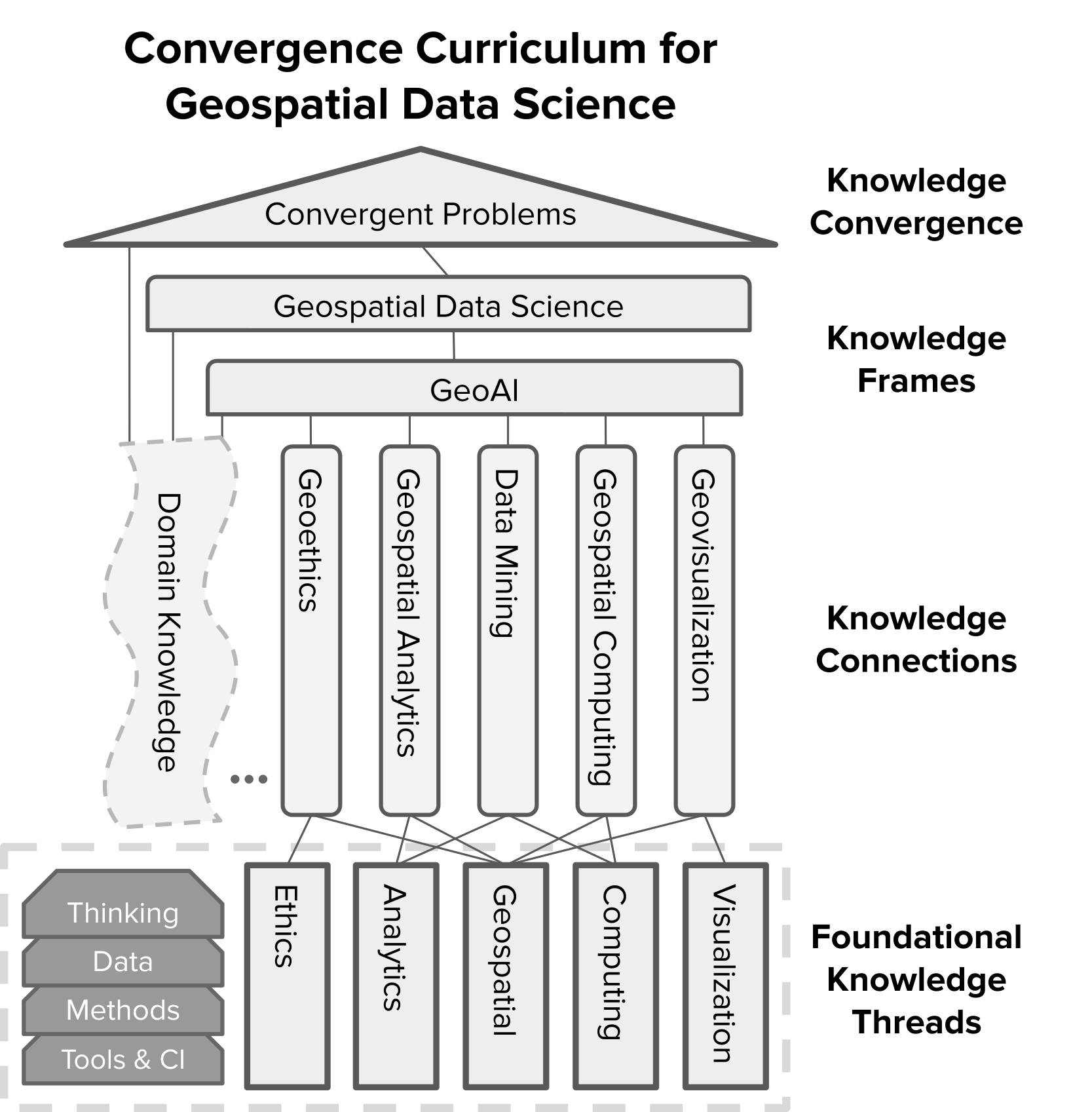
The Convergence Curriculum for Geospatial Data Science is an integrative framework to prepare next-generation students and current-generation scholars and professionals to tackle complex, convergent problems. At its base, the multi-tiered curriculum contains five Foundational Knowledge Threads that establish a common basis for individuals from diverse backgrounds. Each of these threads draws from its own relevant modes of thinking, data, methods, and tools & cyberinfrastructure.
Next, individuals integrate skills, knowledge, methods, and technologies as they move up through Knowledge Connections and Knowledge Frames. As the figure indicates, the Knowledge Connections reflect particular contributions from the Foundational Knowledge Threads.
Finally, the pinnacle of the curriculum is Knowledge Convergence, which blends the previous competencies with pre-existing domain knowledge.
Each component in the curriculum will be available at varying depths: 3 sentences, 3 slides, a 3-hour module, or a 3-week unit. This configuration allows individuals to adapt their experiences to match their learning pathways and needs.
This draft curriculum will continue to be developed, tested, and evaluated. Stay tuned for additional content releases as we continue to expand the curriculum. We are actively seeking feedback from our communities. The curriculum model has already been redesigned multiple times based on community feedback and listening sessions. We intend to continue this iterative approach with the curriculum materials, so please reach out with feedback.
Convergence Curriculum Components
1. Foundational Knowledge Thread (FKT)
2. Knowledge Connections (KC)
3. Knowledge Frames (KF)
4. Domain Knowledge (DK)
5. Knowledge Convergence
6. Community Contributions
Presentations and Community
- I-GUIDE Webinar Series: Navigating the Evolving Educational Landscape in a Convergent Geospatial World
- UCGIS I-GUIDE Community Champions
- The Convergence Curriculum for Geospatial Data Science: Open Resources for You and Your Learners
- I-GUIDE addresses the challenge of computational reproducibility and data ethics by guiding data sharing and ethical decision-making in research practices and AI algorithms