NSF Institute for Geospatial Understanding through an Integrative Discovery Environment (I-GUIDE) enables transformative discovery and innovation for tackling fundamental scientific and societal challenges that are at the cusp of achieving significant breakthroughs by harnessing the vast, diverse, and ever-growing corpus of geospatial data. As most challenging sustainability and resilience problems today require expertise from multiple domains and geospatial data science, I-GUIDE plays a central role in successfully spanning domains, leveraging its multidisciplinary collaboration team and partnerships to achieve geospatial data-intensive discovery and innovation. I-GUIDE also works with related community consortia (e.g., CUAHSI, OGC, and UCGIS) to build consensus and use their inputs when establishing priorities for developing the integrative I-GUIDE platform as a community-oriented discovery environment. The institute fosters open collaboration among diverse communities, bridging the digital divide that hinders participation from underrepresented communities. Through rich education and training programs and by providing access to cutting-edge geospatial data capabilities (e.g., CyberGIS, GeoEDF, and HydroShare), I-GUIDE enables transformative research and education advances across many geospatial-reliant communities while making significant contributions to the national cyberinfrastructure (CI) and Harnessing the Data Revolution (HDR) ecosystems.
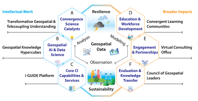
I-GUIDE is organized across six interrelated focus areas: (A) Convergence Science Catalysts; (B) Geospatial Artificial Intelligence (AI) & Data Science; (C) Core CI Capabilities & Services; (D) Education & Workforce Development; (E) Engagement & Partnerships; and (F) Evaluation & Knowledge Transfer. I-GUIDE brings together leaders in scientific research, technical development, education, knowledge transfer, and engagement through focus area teams. This strategy ensures that research, education, broadening participation, and knowledge transfer activities are deeply integrated across the institute from individual teams to the leadership.
I-GUIDE is led by the University of Illinois Urbana-Champaign in collaboration with Columbia University, the Consortium of Universities for the Advancement of Hydrologic Science, Inc. (CUAHSI), Florida International University, Michigan State University, Purdue University, the Open Geospatial Consortium (OGC), University Consortium for Geographic Information Science (UCGIS), University Corporation for Atmospheric Research (UCAR), University of Minnesota Twin Cities, and Utah State University.